January 1, 2016
I had to wake up at about 4:30am to catch my six hour flight to Quito. When we were over Quito, I could see the city lying in a valley surrounded by mountains, it was unlike anything I’ve ever seen. When we finally felt the Ecuadorian air, it was a lot warmer and drier than I expected, I was regularly checking the weather before the trip and it said that it was supposed to rain every day we were in Quito. On our way to our hotel we saw Cotopaxi, unfortunately we won’t be able to visit it because it was showing signs of an eruption. We arrived to our hostel: Hotel Bonaventure, I knew that this was going to be a new, interesting experience. We went to the Plaza Foch and finally got something to eat after about twelve hours of not eating (since I slept through the breakfast on the plane). Quito is unlike any city I have ever seen and I am excited to explore it for the next three days.
January 2, 2016
|
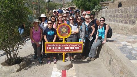
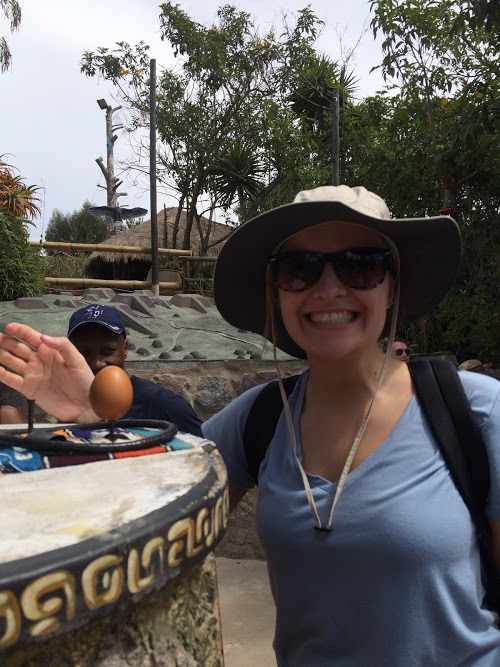
Today was our first full day in Quito, the city means the middle of the world. The city was founded December 6, 1534 by the Spanish. Our first stop was the Intiñan Solar Museum, it marks the equator line. The museum has exhibits about old Ecuadorian culture. We learned how a shrunken head is made: the head is cut off and the skull is removed, the head it then steamed with herbs, hot stones are placed inside the head and that is put in the sun. The indigenous Waorani tribe builds their hut in three days, they use three-thousand leaves, and one hut is home to multiple families. The spears the Waorani people use have two ends: one for hunting animals and another for defending themselves against other tribes. During the Equinox there aren't any shadows on the equator and on the solstice there is light on the equator from 6am to 6pm. Coriolis Effect is caused by Earth’s rotation and causes objects to deflect to the right in the northern hemisphere and left in the southern hemisphere because of this there aren’t any tornadoes, hurricanes of cyclones on the equator. Our guide at the museum had as do several tests that “proved” the equator line was right. We balanced an egg on a nail because it is easier to balance an egg when you’re on the equator. The guide demonstrated how the Coriolis Effect changes north of the line, on the line, and south of it using a sink.
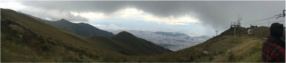
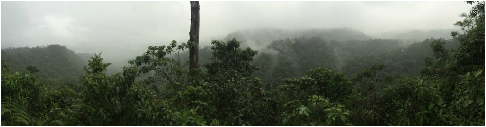
Next we went to Pululahua, which is a dormant volcano, we were supposed to hike but the clouds prevented us. People were killed from its last eruption in 450 BC because they did not know how to track the volcano’s activity. We to Teleferico, which went up the volcano Pichincha, at the top we were 13,200 feet above sea level. We got to see how expansive Quito was, clouds kept coming in and covering parts of the city, the back view was covered the entire time. It was much colder at the top and it was really hard to breath. We had lunch at Centro Historico and visited La Iglesia de la Compañía de Jesús, which is a church that plated in gold. It was absolutely stunning and unlike anything that I have ever seen. |
|
Nick’s cousin is a geologist in Ecuador and he gave us a presentation on the volcanoes and geology of Ecuador. Ecuador is made of four regions: Galapagos Islands, the coast, Amazon, and the highlands. The Galapagos Islands were made from a hotspot, the coast is made up of young sediments, the amazon is made up of old rocks, and the highlands are made of volcanic material. There are at least 84 volcanoes in Ecuador, 60 of those are extinct, 15 potentially active, 5 active, and 4 in eruption. The buildings in Ecuador are made of concrete to help withstand earthquakes. The city of Quito is over the Quito fault, earthquakes are very common in Ecuador. The volcanoes on continental Ecuador are caused by the oceanic Nazca Plate subducting under the continental South American Plate. The descending plate melts and becomes magma. The magma rises through the continental crust, creating volcanoes along the highlands region. (Gleason).
The truth about the equator
Mitad del Mundo is a large monument that was constructed to mark the equator but it is not in the right location. A French geodesic expedition team were responsible for the location of Mitad del Mundo. They mapped out the equator’s location in 1736 but they were off by about 200 meters. (Ecuador.com, 2016). At the Intiñan Solar Museum our guide demonstrated that there is no Coriolis Effect on the equator line using a tub of water. He showed that north of the line the water left the bottom of the tub in a clockwise motion, the south of the line the water moved counter-clockwise out of the tub, but when we were on the equator line it went straight out the bottom of the tub. In reality the Coriolis Effect is so small this close to the equator that it would not be able to be measured or seen. The guide was able to demonstrate a change based on how long the tub sat still for, when we were on the equator it sat still for a while causing the water to leave straight out of the bottom with no vortex. All of the other activities we did at the museum to “prove” we were on the equator line were fixed like the tub, but it was definitely fun participating in the activities. (GypsyNesters, 2015). Below: View from Teleferico
January 3, 2016

|
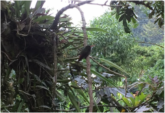
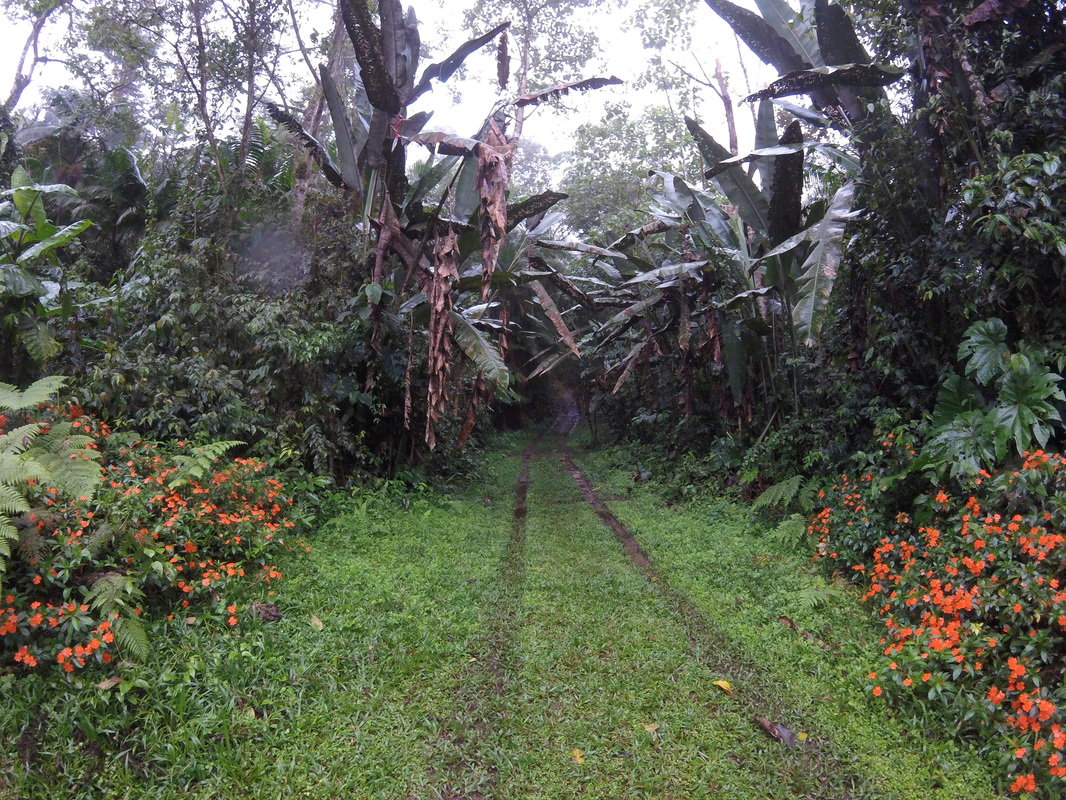
The entire day was spent in Mindo Cloud Forest, a montane forest. On our way to Mindo we almost forgot Sydne at our breakfast stop, Nick was sitting right next her on the bus, he didn’t even notice that she was missing, luckily she came before we left the parking lot. Minto is a secondary forest, meaning that it has been disturbed by human activities. We got to go zip lining in the forest, it was only eight dollars for three lines, much cheaper than it is at home. This was my first time zip lining and it was an amazing experience, the views were astonishing. We stopped at the Rio Mindo to take pictures and there were natives swimming in the water. We ate outside at the Dragonfly Inn, the owner of the inn was from Hoboken. Outside we got to see hummingbirds while we were eating and we also got to see their little farm in the back that was growing limes, tomatoes, and cuye. We watched the clouds roll in over the mountains as we ate lunch.
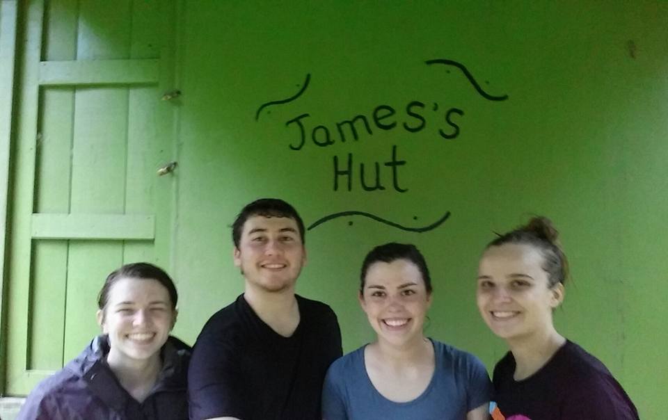
After lunch we went hiking, the trail we were going to go on was closed because it was washed out so we went on a hike at Yellow House Trails & Lodge. On our way up we saw cows, a capybara-looking creature, and a clearwing butterfly. Before we reached the lookout spot it started to lightly rain and we came across a shack that read “James’s Hut”, the door into James’s hut were locked but luckily his hut offered us a break at a picnic table under an awning. We sat there for a while admiring the large leaved plants and the pretty orange flowers. A piece of my soul was left for James for whenever he may return to his hut. We finally left James’s Hut to finish the hike, this is when it started down pouring, but what’s a cloud forest without rain? I actually enjoyed the rain and thought it added to the experience, we finally reached the view and it was stunning, and we were standing in the clouds. When we got to the bottom we had to wait for a few of our classmates to arrive before we could leave, I got to go inside the owner’s house and the view from their porch was just as stunning as the one on the hike, there were at least twenty hummingbirds swarming the feeders on porch. We left Mindo and experienced the most frightening car ride of our lives because our driver was angry with how long we took, I tried to nap but it was not possible with the constant break slamming. |
Cloud forests and climate change
Could forests occur where mountains are engulfed by tradewind-derived orographic clouds and mist with convective rain. During the rainy season cloud forests provide flood and erosion control and water storage during the dry season. Cloud forests are the most endangered of all tropical forests. (Still et al., 1999). The vegetation in cloud forests grows there because of the climate, lower elevations have similar soil and substrate environments but the climate is not suitable for the vegetation. Cloud forests are a unique habitat that is dependent on its climate. If the climate continues warming cloud forests will disappear. (Hays, 2015).
JANUARY 4, 2016
|
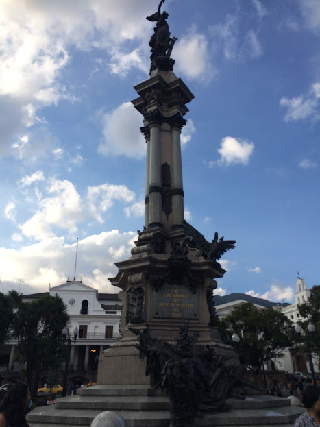
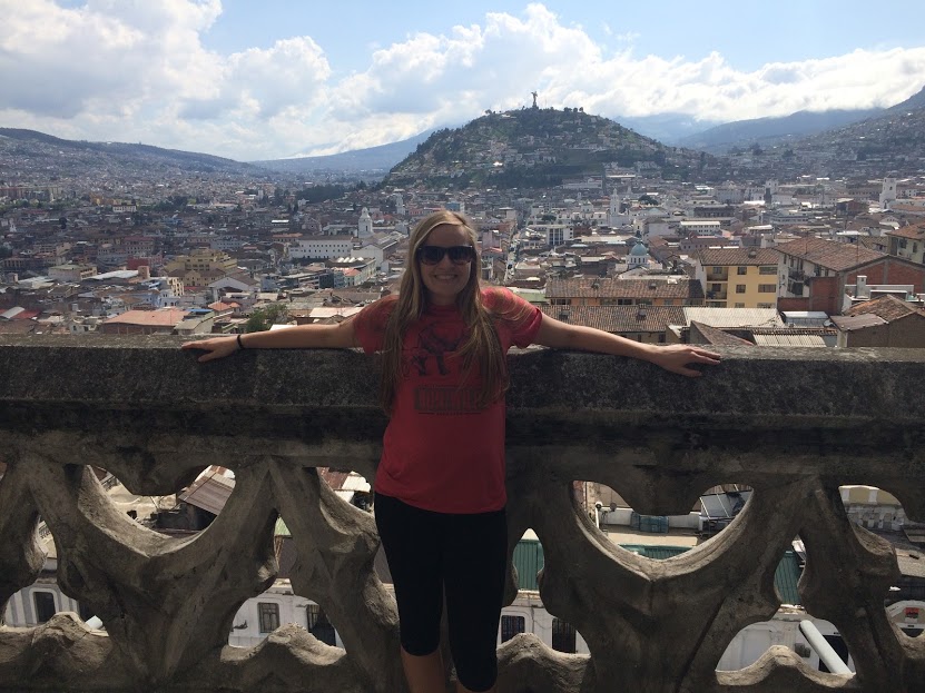
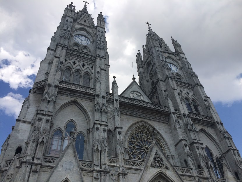
This was our first free day, but we still travelled as a group and saw as much as we could because this was our last day in Quito. We went to the markets and bought souvenirs, a lot of the things in the markets were cheap but a lot of them sold the same items. We went to lunch, I got the lunch special, it was only $3.80 and it came with soup, juice, a pork chop with rice and red beans, and desert. (I am still so surprised how cheap everything is here) We took our first bus ride, it was almost like a bus that you would find in New York City, to Centro Historico. We saw a statue in the square that was dedicated to a rebel who tried to gain Ecuador’s independence. We went to Basílica del Voto Nacional, a Roman Catholic church that has been under construction for 160 year and is still under construction. We climbed to the top of the church and had amazing views of Quito. A school bus then took us to El Panecillo to see the Virgen de Quito statue, and once again we had spectacular views of the city. We took the trolebus back to our hotel, the bus station for it was level with the bus’s floor, boarding the bus was fast and the bus moved faster because cars were not allowed in its lane. For dinner we went to a taco bar and watched Spanish music videos as we ate, my favorite one was when the singers made a crop circle and then took off in a rocket-washing machine.
|
|
|
|
|
Works Cited:
Ecuador.com. (2016). Mitad del Mundo- The Equator. Retrieved from http://www.ecuador.com/sights/mitad-del-mundo/
Gleason, D. (n.d.). Cotopaxi. Retrieved from http://classes.colgate.edu/S08/GEOL220/dmgleason/Location.htm
GypsyNesters. (2015). Getting Centered at the Equator in Ecuador. Retrieved from http://www.gypsynester.com/intinan-museum.htm
Hays, B. (2015). Can cloud forests survive climate change?. Retrieved from http://www.upi.com/Science_News/2015/08/07/Can-cloud-forests-survive-climate-change/2241438962753/
Still, C., Foster, P., Schneider, S. (1999). Stimulating the effects of climate change on tropical montane cloud forests. Nature. 398: 608- 610.
